
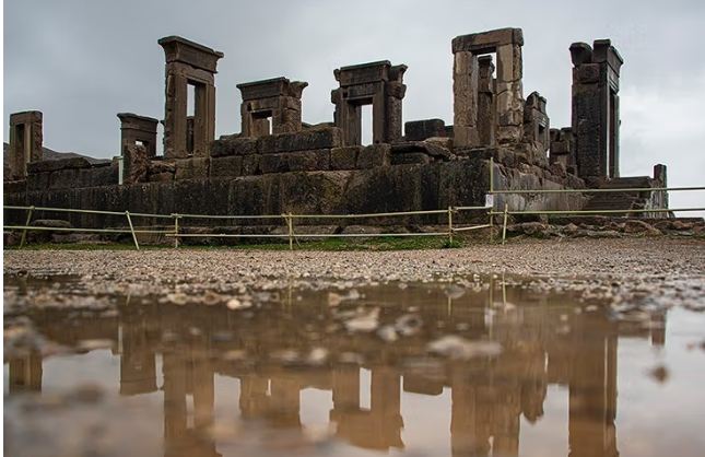
Iran's water crisis is not only threatening natural resources and wildlife. Over the past two years, numerous reports have shown that land subsidence has become a serious danger to the country's historic monuments.
The subsidence crisis, caused by uncontrolled extraction of groundwater, has produced deep cracks in monuments located in cities, plains, and even mountainous regions, and in some cases threatens their very existence.
Subsidence at the historic grounds of Golestan Palace has been one of the most recent instances of this kind of threat to historic buildings.
The 400-year-old Golestan Palace, whose present form dates back to the Zand era, is inscribed on UNESCO's World Heritage list.
The urban fabric surrounding the palace — including the Naser Khosrow Bazaar, historic streets, and the carpet-sellers' rows — forms part of the city's dense, multi-layered fabric, and a network of old qanats (underground aqueducts) circulates subsurface water beneath it.
ISNA has identified the cause of the subsidence at the palace grounds as the “Khan-e Aali” project, formerly known as “Marvi Center” — a shopping center located less than 50 meters from the Shams-ol-Emareh building and within the protective buffer zone of the Mehregerd qanat.
Iran Ranks Third in the World for the Extent of Land Subsidence
Factors Behind the Subsidence of Historic Buildings
Subsidence in historic buildings is usually caused by a combination of factors.
An expert in historic urban fabric and cultural heritage told Iran International that, in the case of the Golestan Palace complex, the drying-up of the qanat is one contributing factor, because when soil loses its moisture and becomes porous, subsidence occurs.
The expert, who asked not to be named in this report, also pointed to subsurface water, adding that because Tehran has substantial elevation changes, during construction, qanats and depressions and pits in the ground are filled in with debris and buildings are erected on top of them; this leaves the ground beneath the structure without stable footing.
According to this expert, when the ground beneath a building is not solid and stable and excavation takes place, the soil is shocked, which leads to subsidence.
He cited Sahebqaranieh Palace as a clear example of this phenomenon, adding that when the Atlas Mall was built within the palace's buffer zone, many qanats and channels were filled in to make way for the shopping center, delivering a major shock to this historic complex.
According to him, these shocks do not reveal themselves right away; just as excavation took place near Sahebqaranieh Palace in 1389 (2010), and the resulting subsidence only became visible in 1394 (2015).
The Khan-e Aali Project, 50 Meters from Golestan Palace
Subsidence at Sahebqaranieh Palace has now reached the point that its doors have long been closed to the public and all its furnishings have been removed.
The same thing happened at the Naqsh-e Jahan and Hasht Behesht complex in Isfahan — unprofessional work that ultimately led to massive subsidence in Isfahan and its historic monuments.
The expert went on to say: “For large construction projects requiring deep excavation, the soil of the area must first be studied. Likewise, this kind of construction must be prevented within the buffer zones of historic monuments.”
He added that, in the case of the Golestan Palace complex, the very short distance between the “Khan-e Aali” project and the Shams-ol-Emareh building and the route of the Mehregerd qanat, combined with the 17-meter depth of the excavation and the resulting pressure on the soil, forms a combination that could cause irreparable damage.
Altering the course of groundwater, blocking qanats, changing soil pressure, and deep excavation can all cause sudden settling, serious cracks in mudbrick walls, and erosion of structural foundations.
The consequence of destroying qanats and groundwater under such conditions is the drying-out of the soil beneath these historic sites, which in turn leads to subsidence.
Reza Salehi Amiri, the Minister of Cultural Heritage, announced on the 23rd of Aban, after visiting “Khan-e Aali,” that he had coordinated with the municipality to issue an order halting the project.
According to him, the judiciary will also seal off the project until technical studies have been completed.
Minister of Cultural Heritage and Tourism: We Have Given the Government an Alarming Report on the Subsidence of Historic Buildings
From Persepolis to Vakil Mosque
Most land subsidence occurs in the central plains of the Iranian plateau, stretching from Tehran and Semnan southward to Isfahan, Fars, and Kerman — regions home to many valuable historic monuments and sites.
Naqsh-e Rostam in Fars province was among the first historic sites where reports of nearby land subsidence emerged.
According to the latest reports, subsidence within 100 meters of Naqsh-e Rostam has reached 9.5 centimeters.
At first, only surface-level restoration was carried out, but after a while the cracks increasingly reasserted themselves, and the effects of soil subsidence eventually became plainly visible.
Tahmoures Yousefi, head of the Geological Survey and Mineral Exploration Center for Iran's southern region, said in an interview with Rokna that cracks have appeared on the slope of the Naqsh-e Rostam site.
The Naqsh-e Rostam site lies six kilometers from Persepolis and carries enormous historical value because of the tombs of four Achaemenid kings and the “Kaaba of Zoroaster” structure located there.
The site is more than 3,200 years old, and notable reliefs and carvings from the Elamite period have also been discovered there.
Mostafa Dehpahlavan, head of the Research Institute of Cultural Heritage, had previously said that Naqsh-e Rostam has been affected by subsidence due to uncontrolled water extraction.
He described surface-level restorations as a “temporary painkiller,” adding that the crisis needs to be resolved in a different way.
Around Marvdasht, in the villages between Naqsh-e Rostam and Persepolis, rice is cultivated using deep wells. Numerous legal cases have been filed over unauthorized water wells in past years, but none have led anywhere.
The effects of subsidence are not confined to the slope of Naqsh-e Rostam alone; cracks are visible across the entire historic Marvdasht site.
Radar data and artificial-intelligence analyses from Shiraz University present an alarming picture of the Marvdasht plain, where the ground sinks by up to 30 centimeters a year and a World Heritage site such as Persepolis is at risk of destruction.
According to a report by the ILNA news agency, more than five thousand unauthorized wells around the Persepolis site are extracting water without restraint — an activity that is depleting groundwater aquifers and making the region's soil porous.
Experts warn that as the planting season begins, an enormous volume of water is drawn out from beneath Persepolis.
The results of a study conducted at Shiraz University between 1400 and 1402 (2021–2024) and submitted to the Tehran Geological Survey Organization in 1403 (2024) show that, over roughly the past 15 years, the entire Marvdasht plain has been grappling with land subsidence.
The scale and speed of this phenomenon in the plain is so great that enormous cracks, ranging from half a meter to 70 centimeters wide, have opened up across Marvdasht.
Experts say that all historic monuments are at risk of destruction because of subsidence, and specialists in the field are raising serious concerns about it.
In addition to the Marvdasht plain, where pre-Islamic archaeological remains are at risk, land subsidence in the Shiraz plain is also seriously threatening the historic fabric of the city of Shiraz.
Warnings About Subsidence in Tehran and the Critical State of 70 Percent of Iran's Plains
Isfahan: Iran's Museum of Architecture
Isfahan, a city known as Iran's cultural capital and an unrivaled example of a city-museum, has now become a symbol of Iran's subsidence crisis and a city at risk of ruin.
These days, subsidence is showing itself in the city's historic buildings, and cracks are clearly visible from the Si-o-Se Pol and Khaju bridges to the Shah (Abbasi) Mosque.
Isfahan's historic architecture belongs to the Safavid style, also known as the Isfahan style, and a considerable number of the city's famous buildings are inscribed on the World Heritage list — testament to their unique character.
Naqsh-e Jahan Square, with all its distinctive buildings, is one of the largest and most beautiful squares in the world.
Experts say that this city, with its unrivaled collection of historic buildings, is subsiding by five centimeters a year.
In Khordad 1402 (mid-2023), a geology expert told the newspaper Ham-Mihan that many historic sites in central Isfahan — including the Hakim Mosque, the Darb-e Imam complex, the Ali Qoli Agha mosque and bathhouse, and other buildings — are affected by subsidence.
Longitudinal cracks can also be seen on the dome of the Seyyed Mosque, indicating subsidence. These cracks are likewise observed at the Shahshahan shrine and the Vazir bathhouse.
At the Atiq Mosque, a remnant of the Seljuk era regarded as the crown jewel of Iranian architecture, the effects of land subsidence are clearly visible.
The rate of land subsidence in parts of Isfahan has been reported at roughly 12 to 18 centimeters a year — a development that threatens not only major historic monuments but also the homes of ordinary residents with collapse.
A University Professor's Warning: Apart From Gilan Province, the Entire Country Is Affected by Subsidence
UNESCO-Listed Sites at Risk of Serious Damage
Ali Beitollahi, head of the Seismology and Risk Assessment Department at Iran's Road, Housing and Urban Development Research Center, had previously said, citing field surveys, that monuments such as Naqsh-e Jahan Square in Isfahan, Persepolis, and Naqsh-e Rostam in Fars province, along with many of Iran's World Heritage-listed archaeological sites, have been damaged by land subsidence.
According to him, of the 63 Iranian sites inscribed on UNESCO's World Heritage list, 27 lie within subsidence-affected zones and are at risk of damage from this phenomenon.
Not long ago, the publication of an image showing a longitudinal crack in part of the Atiq Jameh Mosque of Qazvin — one of Iran's oldest mosques and one of the masterpieces of Iranian architecture — alarmed heritage advocates.
The appearance of gaps and cracks in some of Qazvin's landmark historic buildings has reinforced the theory that these developments are caused by subsidence.
Mohammad Saleh Jokar, the member of parliament for Yazd, had previously stated that land subsidence has created cracks in the city's historic fabric.
Land Subsidence Has Put Persepolis at Risk of Collapse
Caravanserais
In addition to the monuments located within cities, Iran's 41 World Heritage-listed caravanserais are also exposed to subsidence.
Overlaying the map of Iran's subsidence-affected zones with the locations of the country's 54 World Heritage-listed caravanserais shows that only 13 caravanserais — because they sit in mountainous or remote desert areas — have been spared the risk of subsidence.
According to these records, the remaining caravanserais fall within subsidence-affected zones to varying degrees.
Caravanserais facing a high risk of subsidence are located in Isfahan, Semnan, Tehran, Markazi, Alborz, Yazd, Bushehr, Kerman, and South Khorasan provinces.
In this way, symbols of Iran's architecture and national identity are at risk of collapse.
Even if this subsidence were to stop one day, it might be possible to rebuild the cities anew — but the historic monuments will be lost forever.